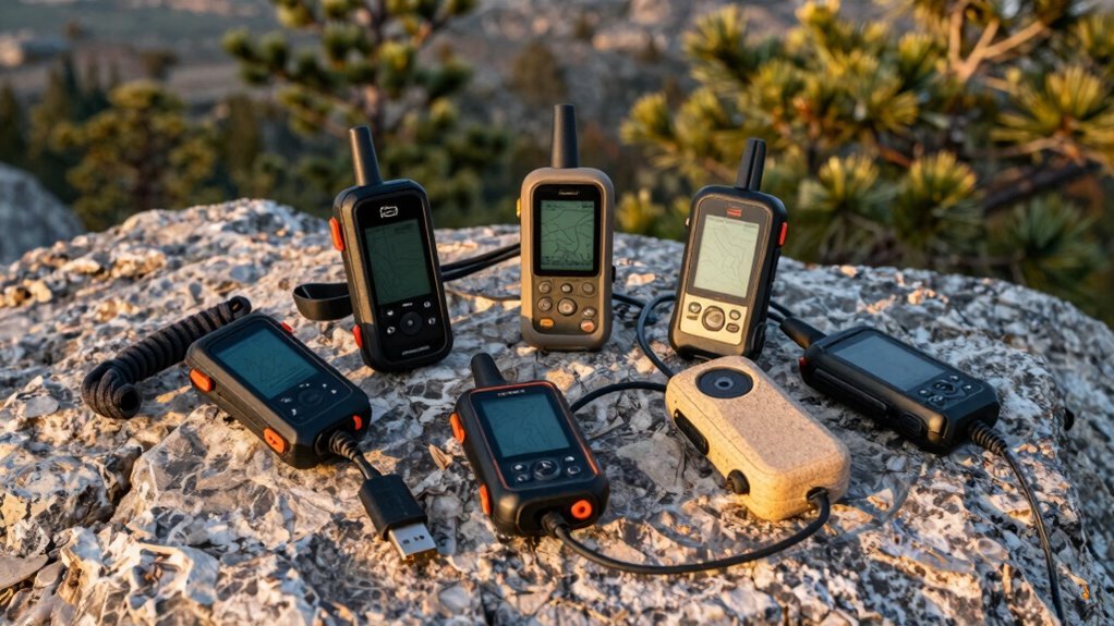
5 Best Handheld GPS Units for Hiking That Never Lose the Trail
You’re out there where the trail fades, trees swallow GPS signals, and rain turns your phone into a paperweight—so why rely on tech that quits when you need it most?
These five best handheld GPS units for hiking don’t just track your location; they lock onto satellites across GPS, GLONASS, and Galileo, with some achieving up to 95% sky coverage.
They’re built to survive the elements, rated to endure 1-meter water immersions for 30 minutes and operate for 20+ hours on a single charge.
Compact and rugged, each handheld fits comfortably in your palm, ready for long backcountry miles.
Wondering which one actually works when gloves, mud, and cloud cover complicate things?
These top performers deliver reliability, precision, and durability when you’re far from civilization.
| Garmin 010-02256-00 eTrex 22x Rugged Handheld GPS Navigator Black/Navy |  | Best for Topo Maps | Display Size: 2.2” | GNSS Support: GPS + GLONASS | Battery Type: 2 AA batteries | VIEW LATEST PRICE | Read Our Analysis |
| Garmin eTrex SE GPS Navigator |  | Longest Battery Life | Display Size: 2.2” | GNSS Support: GPS, GLONASS, Galileo, BeiDou, QZSS | Battery Type: 2 AA batteries | VIEW LATEST PRICE | Read Our Analysis |
| Garmin GPSMAP 65 Handheld (010-02451-00) |  | Most Accurate Navigation | Display Size: 2.6” | GNSS Support: Multi-band GNSS | Battery Type: 2 AA batteries | VIEW LATEST PRICE | Read Our Analysis |
| A6 Handheld GPS for Hiking |  | No-Map Simplicity | Display Size: 2.4” | GNSS Support: GPS, Galileo, BeiDou, QZSS | Battery Type: 3500 mAh Li-ion | VIEW LATEST PRICE | Read Our Analysis |
| Rugged Handheld GPS for Hiking with Topo Map |  | Premium Feature Set | Display Size: 3.2” | GNSS Support: GPS + GALILEO + BEIDOU + QZSS | Battery Type: Rechargeable battery | VIEW LATEST PRICE | Read Our Analysis |
More Details on Our Top Picks
Garmin 010-02256-00 eTrex 22x Rugged Handheld GPS Navigator Black/Navy
If you’re the kind of hiker who ventures beyond cell service and needs reliable navigation without relying on your phone—good news: the Garmin eTrex 22x (model 010-02256-00) won’t quit when things get rough.
You get a sunlight-readable 2.2” color display (240 x 320 pixels) that actually works under harsh glare, plus GPS + GLONASS support for better tracking in deep woods or narrow canyons.
It runs up to 25 hours on just two AA batteries—no charging drama. With 8 GB internal storage and a microSD slot, you can download TopoActive maps and still have room to spare.
Rugged, straightforward, and built for trail reliance, not gimmicks—why carry more than you need?
- Display Size:2.2”
- GNSS Support:GPS + GLONASS
- Battery Type:2 AA batteries
- Water Resistance:Not specified
- Preloaded Maps:Topo Active maps
- Physical Buttons:Yes
- Additional Feature:Preloaded Topo Active maps
- Additional Feature:8 GB internal memory
- Additional Feature:25-hour battery life
Garmin eTrex SE GPS Navigator
You’ll want the Garmin eTrex SE GPS Navigator if you’re a dedicated hiker who values long battery life, rugged reliability, and consistent satellite reception—especially when venturing into remote areas where smartphones fail.
You get a 2.2” sunlight-readable display and IPX7 waterproofing, so rain or shine, you’re covered—literally. With up to 168 hours in standard mode (or 1,800 in expedition!), plus two AA batteries you can swap mid-trail, you’ll never gamble on power.
It tracks GPS, GLONASS, Galileo, BeiDou, and QZSS—so, yeah, you’ll have signal even under dense tree cover. The built-in compass gives accurate headings while standing still, which, let’s be honest, happens more than we’d like.
Paired with the Garmin Explore app, you get live Geocaching updates, trip planning, and smart notifications—because even off-grid, you might still care about that text from Mom.
- Display Size:2.2”
- GNSS Support:GPS, GLONASS, Galileo, BeiDou, QZSS
- Battery Type:2 AA batteries
- Water Resistance:IPX7
- Preloaded Maps:Not specified
- Physical Buttons:Yes
- Additional Feature:Multi-GNSS satellite support
- Additional Feature:Expedition mode (1,800 hrs)
- Additional Feature:Geocaching Live cache updates
Garmin GPSMAP 65 Handheld (010-02451-00)
The Garmin GPSMAP 65 (010-02451-00) stands out for hikers who demand reliability in tough terrain. Its 2.6” sunlight-readable display stays visible even under tree canopies or canyon walls, so you won’t squint like you’re decoding a blurry text at arm’s length.
You’ll tap into expanded GNSS satellites and multi-band tech, which team up to nail your position within feet, not football fields. This precision shines where signals usually fray—think dense forests or narrow gullies.
With TopoActive maps, you can route on trails and even load federal land boundaries if you’re roaming the U.S. Though you’ll need a smartphone plus the Garmin Explore app to tweak routes or track stats, that’s just the price of modern GPS synergy.
- Display Size:2.6”
- GNSS Support:Multi-band GNSS
- Battery Type:2 AA batteries
- Water Resistance:Not specified
- Preloaded Maps:TopoActive mapping, federal public land map
- Physical Buttons:Button-Operated
- Additional Feature:Multi-band technology
- Additional Feature:Federal public land map
- Additional Feature:Garmin Explore app compatible
A6 Handheld GPS for Hiking
Who needs pinpoint accuracy when the trail disappears and the trees close in? With the A6 Handheld GPS, you’ve got multi-GNSS support—GPS, Galileo, BeiDou, and QZSS—locking onto signals fast, even under dense canopy, delivering position accuracy within 5 feet.
Its 2.4-inch sunlight-readable color display stays crisp, while the rugged, waterproof build and non-slip sides keep it secure in wet or cold conditions. Physical buttons mean you won’t fumble with touchscreens with gloves.
You can store up to 1,000 waypoints, record tracks, and retrace your steps with confidence. Though remember: no built-in maps, so rely on coordinates and compass skills.
- Display Size:2.4”
- GNSS Support:GPS, Galileo, BeiDou, QZSS
- Battery Type:3500 mAh Li-ion
- Water Resistance:Waterproof
- Preloaded Maps:No built-in map
- Physical Buttons:Physical buttons
- Additional Feature:1000-waypoint capacity
- Additional Feature:Barometric altimeter
- Additional Feature:Sunrise/sunset information
Rugged Handheld GPS for Hiking with Topo Map
Serious hikers who demand reliability when the trail vanishes—and honestly, who hasn’t second-guessed a switchback in the fog—will appreciate a rugged handheld GPS built to endure storms, drops, and days off-grid. You’ll grab this compact, lightweight navigator with its anti-slip grip and physical buttons—no fumbling with touchscreens mid-downpour.
Its 3.2″ sunlight-readable display stays clear even under harsh alpine glare. With multi-GNSS support (GPS, Galileo, BeiDou, QZSS), you’re getting positioning within 6 ft.
A 3-axis compass and barometric altimeter ensure accurate heading and elevation, even when standing still. The device is IP66-rated, so you’ll hike fearlessly in deluges.
The 36-hour battery life, charged via USB-C, keeps working when satellite maps eat power. Preloaded USA Topo maps cover your basics, while 32 GB of internal memory lets you download serious terrain detail—no sketchy trail guesses at 10,000 feet.
- Display Size:3.2”
- GNSS Support:GPS + GALILEO + BEIDOU + QZSS
- Battery Type:Rechargeable battery
- Water Resistance:IP66
- Preloaded Maps:USA Topo maps
- Physical Buttons:Physical buttons
- Additional Feature:36-hour battery life
- Additional Feature:32 GB internal storage
- Additional Feature:3.2” sunlight-readable screen
Factors to Consider When Choosing Handheld GPS Units for Hiking
You’ll want to keep display clarity and size in mind—nobody’s reading a 2.5-inch screen in direct sunlight, right? Think about battery life and type, especially if you’re relying on AA batteries for multi-day treks instead of a built-in lithium pack. And don’t overlook mapping features, memory capacity, ruggedness, weather resistance, or how well your unit locks onto GPS, GLONASS, and Galileo signals in dense tree cover.
Display Clarity and Size
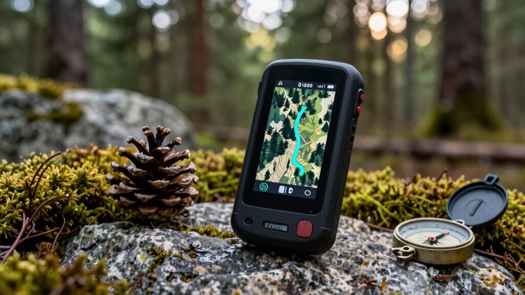
Ever wonder why some trail screens seem to vanish in direct sunlight while others stay sharp and clear? It’s likely because they’ve got sunlight-readable displays—some even with 240 x 320 pixel resolution—so you don’t squint trying to read your route.
You’ll find screens ranging from 2.2 to 3.2 inches, giving you room to see maps without cramping your pack space. Most use color displays (2.2”–2.6” is common), making terrain features easier to distinguish—especially when you’re staring down a steep ridge or a river crossing.
But keep in mind: if your unit lacks built-in maps, clarity depends on how well your downloaded topo files render. Higher resolution helps, but so does screen brightness and anti-glare tech.
You want crisp text, vibrant waypoints, and no guessing games when the trail forks—because, let’s be honest, you won’t have time to play “Where’s Waldo?” with your compass.
Battery Life and Type
How long can you really depend on your GPS before it taps out mid-trail? If you’re using AA batteries, you’ll typically get up to 25 hours in GPS mode—enough for a long weekend, but not a thru-hike.
Some models stretch to 168 hours in standard mode or even 1,800 in expedition mode, cutting power to non-essentials (like continuous screen refresh) to eke out every second. Rechargeable Li-ion packs offer around 36 hours, which is great—until you’re trailside with no outlet in sight.
Your choice between AAs and built-in batteries affects more than just runtime; it shapes how you pack (weight, spares) and whether you can swap power on the fly. Keep in mind: using multi-GNSS, bright screens, or active sensors slashes battery life fast—so dialing back settings isn’t wimpy, it’s smart hiking.
Mapping Features and Memory
Peering at a detailed topo map mid-hike beats squinting at a crumpled paper trail guide. Especially when that map lives right on your GPS screen, preloaded and ready.
You’re not just guessing your location; with multi-GNSS support (GPS, GLONASS, Galileo, BeiDou), your position stays accurate even under thick canopy or in narrow canyons. Where would you rather be lost?
Most units come with routable topo maps covering trails and roads, so you can follow established paths with confidence. Internal memory ranges from 8 GB to 32 GB, plenty for large backcountry zones.
If that’s not enough, microSD slots let you expand storage on the fly. Using companion apps, you wirelessly update maps, organize routes, and transfer data without fuss.
Sure, you could still fold a paper map with your boot, but why would you? Modern mapping just works—when you need it most.
Durability and Weather Resistance
You’re relying on crisp topo maps and multi-GNSS accuracy to keep you on trail, but none of that matters if your GPS conks out when dropped in a creek or soaked in a sudden thunderstorm. You need IPX7 or IP66 ratings—meaning it can survive 30 minutes underwater or heavy downpours.
Sealed, reinforced housings keep dust and dirt out, even on dry, gritty switchbacks. Rugged builds handle drops and vibrations, so tossing it in your pack won’t spell disaster.
Physical buttons are a must—ever tried swiping a touchscreen with wet fingers or gloves? Exactly.
These units endure extreme temps, from frigid alpine mornings to desert afternoons, without glitching. Sure, no device is *truly* indestructible (drop it off a cliff and, well, RIP), but with military-grade resilience, you’re covered.
The best part? All this toughness works silently in the background—no fanfare, no fuss—so you focus on the hike, not the hardware.
Navigation Accuracy and Satellites
Reliability isn’t just about surviving the elements—it’s about knowing exactly where you are when the trail vanishes under snow or dense canopy. You need a handheld GPS that locks onto multiple satellite networks (GPS, GLONASS, Galileo, BeiDou, even QZSS) so you’re not left guessing in steep valleys or thick forest.
With multi-GNSS support, you’ll pull in signals from over 30 satellites—sometimes twice as many as GPS alone—slashing lock times and cutting drift. Add multi-band tech, and accuracy stays under 5 feet, even beneath leafy canopies or canyon walls.
Sure, open sky’s ideal, but when signals fade, built-in sensors like barometric altimeters and 3-axis compasses keep your heading steady. Think of them as silent partners—tiny, sure, but essential when satellites drop the ball.
They don’t just fill gaps; they smooth out noisy data, so your track log stays clean. Isn’t that what real trail confidence looks like?
Frequently Asked Questions
How Long Do GPS Batteries Last on Average?
GPS batteries last about 15 to 20 hours on average. You’ll need to charge them nightly on long hikes. Some models get up to 30 hours, but you’re safer assuming less, especially if you’re using extra features like backlight or wireless connectivity.
Can Handheld GPS Units Track Heart Rate?
No, you can’t track heart rate with most handheld GPS units. Remember when Sarah pushed too hard on a ridge, dizzy and drained? Your watch handles the heartbeat; your GPS just marks the path—keep them both, stay safe, and let each do what it’s built for.
Are GPS Devices Waterproof or Just Water-Resistant?
Most GPS devices are water-resistant, not fully waterproof, so they handle rain and splashes fine. You can submerge some models briefly, but check the IP or ATM rating. Always avoid deep water—don’t assume yours can survive a river dunk.
Do GPS Units Work Without Cell Service?
Yes, GPS units work without cell service. You’re tracking through Alaska’s Denali National Park, deep in a valley—no signal, but your device pins your location using satellite signals, guiding you to camp safely when phones fail.
Can I Connect a GPS to My Smartphone?
Yes, you can connect your GPS to your smartphone via Bluetooth or Wi-Fi. You’ll pair them through the device settings, and the GPS boosts your phone’s location accuracy, especially in remote areas where signals are weak or nonexistent.
Conclusion
You’re not just buying a gadget—you’re strapping a digital compass rose to your palm, one that won’t flinch at rain, drops, or 20-hour battery drains. These units blend multi-GNSS (GPS, GLONASS, Galileo) with barometric altimeters and 3-axis compasses—no, they won’t cook your dinner, but they *will* keep you found when trails vanish like Wi-Fi in the woods.